The backcountry and wilderness areas of Crystal Cove State Park offer you 18 miles of hiking trails through 2,400 acres of native wilderness – mostly the endangered coastal sage scrub plant community. For energetic backpackers, there are three environmental campgrounds, one in the canyon and two at higher elevations. The higher trails offer beautiful vistas of the mountainous backcountry, geological formations, and the Pacific Ocean. Exploring the lower trails offers hiking through riparian woodlands with oak and sycamore trees along the seasonal Moro Creek. Whether you explore the high trails or the low trails or both, you will find ample evidence of native plants and animals, and a sense of escaping from civilization into the beautiful solitude of the natural world.
Hiking Trails:
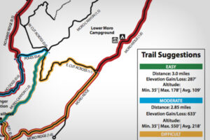
Easy Out and Back
Moro Canyon
About 1 hour, elevation 35’-178’, distance 3.0 miles
Starting at the Ranger Station, walk downhill and turn left onto the dirt trail before the campground. Continue along the dirt to the long bridge. Once you cross the bridge, you will be in beautiful Moro Canyon. Continue up the Moro Canyon Trail until you reach the junction with the Poles Trail and West Cut Across. Go out the same way you hiked in.
Moderate Loop Trail – No Dogs
Poles/Moro Canyon
About 1 hour, elevation 35’-550’, distance 2.85 miles
Starting at the Ranger Station, walk uphill to the dirt road past a gate. This is the No Dogs Trail which is a short, but moderately uphill hike. Follow the trail until you reach the intersection with Poles Trail which is a steep descent (electric poles mark the way downhill.) At the end of the Poles Trail you will intersect Moro Canyon and West Cut Across Trails. Turn right, downhill on Moro Canyon Trail, cross the long bridge, and bear right up a moderate uphill climb, past the campground and back to the parking lot.
Difficult Loop Trail
Moro Canyon / Easy Cut Across / Moro Ridge / BFI
About 2 hours, elevation 35’-740’, distance is about 5 miles
Starting at the Ranger Station, walk downhill and turn left onto the dirt trail before the campground. Continue along the dirt to the long bridge. Once you cross the bridge, you will be in beautiful Moro Canyon. Continue up the Moro Canyon Trail (~ 1 mile) until you reach the East Cut Across Trail. Turn right and climb the steep, winding uphill to Moro Ridge (~ 1.1 mile). Turn right towards the ocean and as you near the Coast Highway (~1.6 mile) look for BFI Trail. Turn right on this short trail with some steep single-track which connects with Moro Canyon. Turn left, cross the long bridge, and bear right up a moderate uphill climb, past the campground and back to the parking lot.
Strenuous Loop Trail
Park Perimeter
About 4.5 hours, elevation 35’-1000’, distance is about 9 miles
This route is the best way to experience the whole backcountry. Take plenty of water and a snack and stop at one of the three environmental campsites for a view, a rest, or to use the portable toilets. Starting at the Ranger Station, walk uphill to the dirt road past a gate. This is the No Dogs Trail which is a short, but moderately uphill hike. No Dogs Trail connects with No Name Ridge (bear left) which has several ups and downs. Pass the junction with West Cut Across Trail staying on No Name Ridge until you turn downhill (right) onto Ticketron Trail. This single-track leads to Deer Canyon and Campground. Climb uphill from Deer Canyon to Red Tail Ridge, bear left to near the park boundary gate. Turn right onto Fenceline Trail (single-track) eastbound which becomes Missing Link Trail (single track) and ends at Moro Ridge. Turn right on Moro Ridge which runs along the southeastern boundary of the park. Stay on the ridge for 3+ miles, and turn right onto the single-track BFI Trail. This trail leads to Moro Canyon Trail where you turn left, go over the long bridge, bear right uphill, past the campground and back to the parking lot.
-
Trail Map
A map and details of the Crystal Cove hiking trails.
CLICK HERE TO VIEW MAP